About

Hello there 👋, I'm Changjie Chen, Ph.D., an urban planner and statistician. My research leverages geospatial analysis, machine learning, and High-Performance Computing (HPC) to inform decision-making about integrated land use and transportation systems.

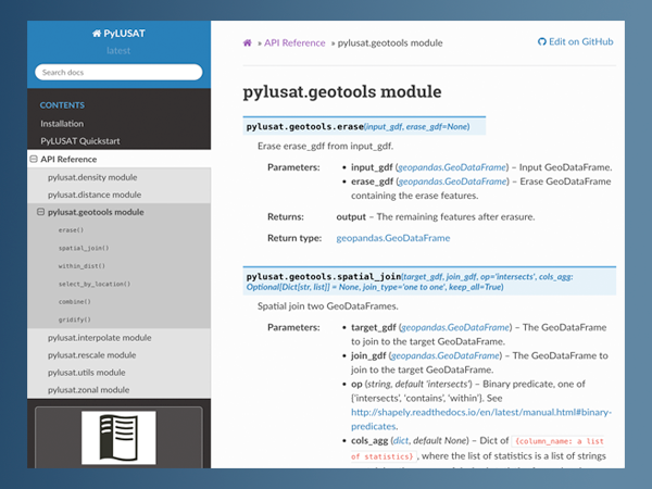
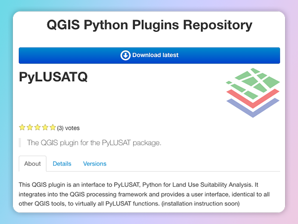
I am passionate about developing open-source Geographic Information System (GIS) tools. Through the SERVIR program, a joint initiative by NASA and USAID, some of the tools I developed are actively used by urban planners and GIS professionals in Ghana and other West African countries.

Focus

  • planning icon

    Urban planning

    Improve built environment resilience through land use planning.

  • ai icon

    Artificial intelligence

    Apply HPC and machine learning to solve planning issues.

  • GIS development icon

    GIS

    Development and Application of the Geographic Information System.

  • 3d visual icon

    Data visualization

    Build interactive web apps for 3D data visualization and animation.

Recent Work Highlights

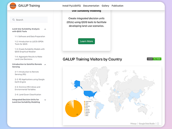
Ghana Land Use Project (GALUP)
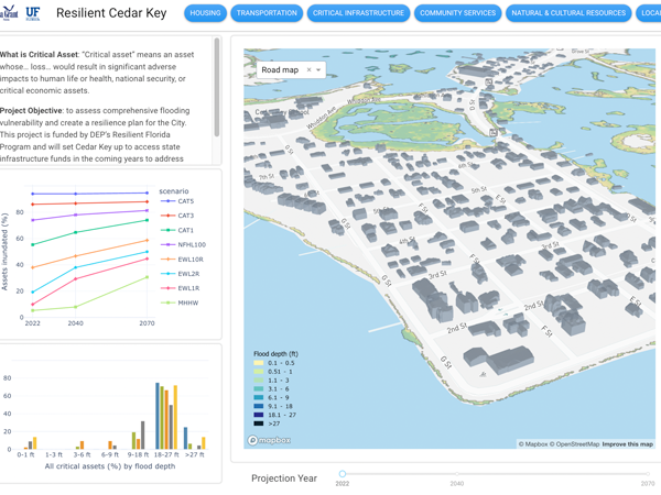
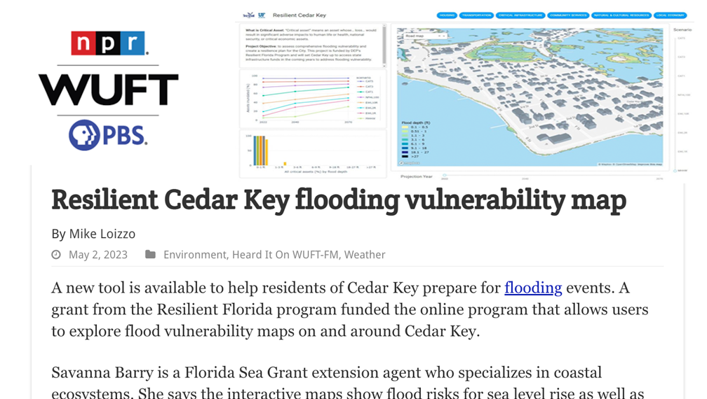
Resilient Cedar Key

cdk news

Teaching

Resume

Education

  1. Ph.D. in Design Constuction and Planning

    2015 — 2019

    College of Design, Construction, and Planning, University of Florida, USA

  2. Master of Statistics

    2017 — 2021

    Department of Statistics, University of Florida, USA

  3. Master of Arts in Urban and Regional Planning

    2012 — 2014

    Department of Urban and Regional Planning, University of Florida, USA

  4. Bachelor of Science

    2007 — 2011

    School of Geomatics, Liaoning Technical University, China

Experience

  1. Postdoctoral Associate

    2019 — Present

    Florida Institute for Built Environment Resilience (FIBER), University of Florida, FL, USA

  2. GIS Supervisor

    2015 — 2017

    Public Works Department, City of Gainesville, FL, USA

  3. Assistant Transit Planner

    2014 — 2015

    Regional Transit System (RTS), City of Gainesville, FL, USA

Programming Languages

  • Python
    90%
  • R
    80%
  • C#
    50%
  • HTML, CSS, JavaScript
    70%
  • SQL
    60%

Research

Publications

  1. Brown, M., Chen, C., Thirumala, K., Lu, C., Wang, L., Das, S., & Woods, J. 2023. Visualizing and Tagging Trail Experiences. Journal of Digital Landscape Architecture, 8-23, . DOI: 10.14627/537740026 .

  2. Chen C., Judge J., Hulse D. 2022. PyLUSAT: An open-source Python toolkit for GIS-based land use suitability analysis. Environmental Modelling & Software . DOI: 10.1016/j.envsoft.2022.105362 .

  3. Chen C., Wang L., Murtha T., Hulse D. 2022. Lessons from livestreaming fieldtrips: Evaluating an alternative fieldtrip approach in teaching landscape architectural studios. Journal of Digital Landscape Architecture , 7-22. DOI: 10.14627/537724057 .

  4. Han Y., Chen C., Peng Z, Mozumder P. 2022. Evaluating the Impacts of Coastal Flood Damage on Transportation System using an activity-based travel demand model: a case study in Miami-Dade County, FL. Transportation . DOI: 10.1007/s11116-021-10172-w .

  5. Fang J., Yan X., Bejleri I., Chen C. 2022. Which trip destination matters? Estimating the influence of the built environment on mode choice for home-based complex tours. Transport Geography , DOI: 10.1016/j.jtrangeo.2022.103474 .

  6. Brown M., Chen C., Wang L., Murtha T. 2022. Identifying cultural resource hotspots via crowdsourcing and expert perspectives in the Eastern US. Journal of Digital Landscape Architecture , 7-2022, DOI: 10.14627/537724016 .

  7. Wang Y., Rahimi-Golkhandan A., Chen C., Taylor J., Garvin M. 2019. Measuring the Impact of Transportation Diversity on Disaster Resilience in Urban Communities: Case Study of Hurricane Harvey in Houston, TX. Computing in Civil Engineering 2019: Smart Cities, Sustainability, and Resilience . DOI: 10.1061/9780784482445.071 .

Grants

  1. NASA/USAID SERVIR (80NSSC23K0247). Linking deforestation, urbanization, and agricultural expansion for land-use decisions in Ghana . 2020-2023. $660,286.

  2. NASA/USAID SERVIR (80NSSC20K0153). Integrating socio-economic and remotely sensed information to characterize conflict precursors and land degradation dynamics in Ghana . 2023-2025. $659,774.

  3. Florida Department of Environment Projection (22PLN11). Resilient Port St. Joe .. 2022-2024. $218,895.

  4. Florida Department of Environment Projection (22PLN38). Assessment and Planning for a Resilient Cedar Key.. 2022-2024. $185,000.

present icon

Conference Presentations

  1. Judge J., Chen C., Singh A., Peeling J. Kiker G., Mensah F., Walther O., Owusu-Sekyere C. 2022. GALUP: Transformative land use planning in Ghana through satellite observations, suitability modeling, and stakeholder engagement. American Geophysical Union (AGU) 2022.

  2. Peeling J., Chen C., Singh A., Judge J. 2022. Integrating time series remote sensing information in suitability analysis for land use planning. International Geoscience and Remote Sensing Symposium (IGARSS) 2022. DOI: 10.1109/IGARSS46834.2022.9883685 .

  3. Chen C., Judge J., Kiker G., Peeling J. 2021. Building capacity for decision makers in Ghana for sustainable land use planning using earth observations and open-source GIS tools. American Geophysical Union (AGU) Fall 2021. DOI: 10.1002/essoar.10509617.1 .

  4. Chen C. 2021. Massive land-use suitability analysis based on parallel computing: A case study in Orange County, Florida. Association of Collegiate Schools of Planning (ACSP) 61st Annual Conference.

  5. Wang L., Chen C. 2021. Assessing a suitable infrastructure land system. International Geodesign Collaboration (IGC) conference.

  6. Noh S., Bejleri I., Zhai L., Chen C. 2021. Measuring and improving accessibility to public transit: the Transit Accessibility Analyst (TAA) Application. Transportation Research Board (TRB) National Transportation Planning Applications Conference .

Contact

Contact Form